|
About
United Arab Emirates
The UAE lies between 22°50' and 26° north latitude
and between 51° and 56°25' east longitude. It shares a nineteen kilometer
border with Qatar on the northwest, a 530-kilometer border with Saudi
Arabia on the west, south, and southeast, and a 450-kilometer border
with Oman on the southeast and northeast. The largest emirate, Abu Dhabi,
accounts for 87 percent of the UAE's total area (67,340 square kilometers).
The smallest emirate, Ajman, encompasses only 259 square kilometers
51° and 56°25' east longitude. It shares a nineteen kilometer
border with Qatar on the northwest, a 530-kilometer border with Saudi
Arabia on the west, south, and southeast, and a 450-kilometer border
with Oman on the southeast and northeast. The largest emirate, Abu Dhabi,
accounts for 87 percent of the UAE's total area (67,340 square kilometers).
The smallest emirate, Ajman, encompasses only 259 square kilometers
The UAE stretches for more than 650 kilometers along the southern shore
of the Persian Gulf. Most of the coast consists of salt pans that extend
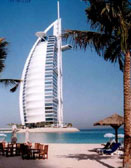
far inland. The largest natural harbor is at Dubai, although other ports
have been dredged at Abu Dhabi, Sharjah, and elsewhere. Numerous islands
are found in the gulf. The smaller islands, as well as many coral reefs
and shifting sandbars, are a menace to navigation. Strong tides and
occasional windstorms further complicate ship movements near the shore.
 The
UAE also extends for about ninety kilometers along the Gulf of Oman,
an area known as the Al Batinah coast. The Al Hajar al Gharbi (Western
Al Hajar) Mountains, rising in places to 2,500 meters, separate the
Al Batinah coast from the rest of the UAE. Beginning at the UAE-Oman
border on the Persian Gulf coast of the Musandam Peninsula (Ras Musandam),
the Al Hajar al Gharbi Mountains extend southeastward for about 150
kilometers to the southernmost UAE-Oman frontier on the Gulf of Oman.
The range continues as the Al Hajar ash Sharqi (Eastern Al Hajar) Mountains
for more than 500 kilometers into Oman. The mountain slopes tend to
run right to the shore. Nevertheless, there are small harbors at Diba
al Hisn, Kalba, and Khor Fakkan on the Gulf of Oman. In the vicinity
of Fujeirah, where the mountains do not approach the coast, there are
sandy beaches. The
UAE also extends for about ninety kilometers along the Gulf of Oman,
an area known as the Al Batinah coast. The Al Hajar al Gharbi (Western
Al Hajar) Mountains, rising in places to 2,500 meters, separate the
Al Batinah coast from the rest of the UAE. Beginning at the UAE-Oman
border on the Persian Gulf coast of the Musandam Peninsula (Ras Musandam),
the Al Hajar al Gharbi Mountains extend southeastward for about 150
kilometers to the southernmost UAE-Oman frontier on the Gulf of Oman.
The range continues as the Al Hajar ash Sharqi (Eastern Al Hajar) Mountains
for more than 500 kilometers into Oman. The mountain slopes tend to
run right to the shore. Nevertheless, there are small harbors at Diba
al Hisn, Kalba, and Khor Fakkan on the Gulf of Oman. In the vicinity
of Fujeirah, where the mountains do not approach the coast, there are
sandy beaches.
South and west of Abu Dhabi, vast, rolling sand dunes merge into the
Rub al Khali (Empty Quarter) of Saudi Arabia. The desert area of Abu
Dhabi includes two important oases with adequate underground water for permanent settlements and cultivation. The extensive Al Liwa
Oasis is in the south near the border with Saudi Arabia. About 100 kilometers
to the northeast of the Al Liwa Oasis is the Al Buraimi Oasis, which
extends on both sides of the Abu Dhabi-Oman border.
water for permanent settlements and cultivation. The extensive Al Liwa
Oasis is in the south near the border with Saudi Arabia. About 100 kilometers
to the northeast of the Al Liwa Oasis is the Al Buraimi Oasis, which
extends on both sides of the Abu Dhabi-Oman border.
Prior to withdrawing from the area in 1971, Britain delineated the internal
borders among the seven emirates in order to preempt territorial disputes
that might hamper formation of the federation. In general, the rulers
of the emirates accepted the British intervention.
The climate of the UAE generally is hot and dry. The hottest months
are July and August, when  average
maximum temperatures reach above 48° C on the coastal plain. In
the Al Hajar al Gharbi Mountains, temperatures are considerably cooler,
a result of increased altitude. Average minimum temperatures in January
and February are between 10° C and 14° C. During the late summer
months, a humid southeastern wind known as the sharqi makes the coastal
region especially unpleasant. The average annual rainfall in the coastal
area is fewer than 120 millimeters, but in some mountainous areas annual
rainfall often reaches 350 millimeters. Rain in the coastal region falls
in short, torrential bursts during the summer months, sometimes resulting
in floods in ordinarily dry wadi beds. The region is prone to occasional,
violent dust storms, which can severely reduce visibility. average
maximum temperatures reach above 48° C on the coastal plain. In
the Al Hajar al Gharbi Mountains, temperatures are considerably cooler,
a result of increased altitude. Average minimum temperatures in January
and February are between 10° C and 14° C. During the late summer
months, a humid southeastern wind known as the sharqi makes the coastal
region especially unpleasant. The average annual rainfall in the coastal
area is fewer than 120 millimeters, but in some mountainous areas annual
rainfall often reaches 350 millimeters. Rain in the coastal region falls
in short, torrential bursts during the summer months, sometimes resulting
in floods in ordinarily dry wadi beds. The region is prone to occasional,
violent dust storms, which can severely reduce visibility.
|